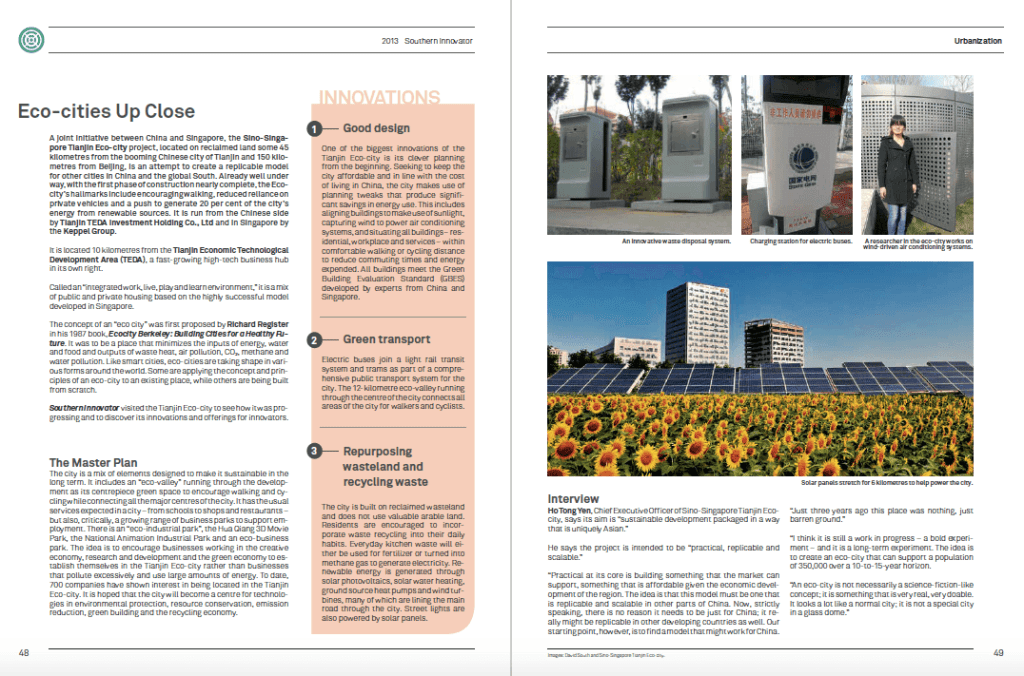
Tag: South-South Solutions

  • Model City to Test the New Urbanism Concept in India

    Model City to Test the New Urbanism Concept in India

    By David SouthDevelopment Challenges, South-South Solutions

    SOUTH-SOUTH CASE STUDY

    India’s phenomenal economic growth rate – forecast to be 7.9 percent this year by the Asian Development Bank, after averaging 7.7 percent per year over the past decade – has been the force behind an expanding middle class population, now estimated at 50 million people (McKinsey). Forecasts see it swelling from 5 percent of the population to 40 percent by 2025.

    India now boasts many fast-growing global companies and booming enterprise zones like the technology hub of Bangalore. But the country still comes in for heavy criticism of the way it has managed the growth of its cities. Poor planning and chaotic growth have left many cities with vast slum areas, congestion, poor hygiene and sanitation services, crumbling infrastructure and poor-quality transportation services. To more and more Indians it has become clear these factors are now serious impediments to economic growth and modernisation of the country and its economy.

    With 30 percent of the population living in urban areas and cities contributing 60 percent of the country’s GDP and 90 percent of government revenues (Wall Street Journal), city-dwellers’ fate is critical to the functioning of the economy.

    According to the 2001 Indian census, slums make up 25 percent of all housing, and 26 percent of urban households lack access to sanitation facilities.

    And as the middle class grows and its members accumulate savings, their desire to be better housed will also grow. They will be on the hunt for new places to live to realise their dreams. Those who can satisfy this strong urge will be those who will also profit.

    This is where the new city concept of Lavasa (www.lavasa.com) comes in. This new community sits nestled in picturesque mountains and features promenades, sidewalk cafes, and ice cream parlours, but none of the clichéd fixtures of today’s Indian cities: rickshaws, noise and pollution, poor sanitation and over-crowding. It has apartment houses in mustard, terra cotta, ochre, olive and beige. It is also going to have a medical campus, luxury hotels, boarding schools, sports academies, a golf course, a space camp, animation and film studios, software-development companies, biotech labs and law and architectural companies. A thoroughly ‘knowledge economy’ mix that India’s aspiring classes wish to see the country embrace for its future development.

    The people behind Lavasa see it as a new model of governance and urban development for India in the 21st century.

    Lavasa is located in Western Ghats, 200 kilometres southeast of Mumbai, India’s financial and entertainment capital, and 65 kilometres west of Pune, a centre for software programming and computer animation.

    Lavasa’s colourful and detailed website boasts it as a “private hill city being developed by Lavasa Corporation Limited where people can live, work, learn and play in harmony with nature.” It’s billed as “an inclusive city, based on the principles of New Urbanism.”

    The master plan is to house more than 300,000 people divided in to five linked towns.

    The first town, Dasve, will be completed in 2011. Its houses are selling well and are almost sold out, according to its developers.

    Lavasa is the concept of Ajit Gulabchand, chairman of Hindustan Construction Company, an Indian company with extensive experience building bridges and dams.

    The development is located in the remote hills along the Varasgaon Lake, a reservoir providing water to Pune. Lavasa Hill City covers “25,000 acres with 60 Kms of lakefront” according to its website. The land had originally been designated for holiday homes, but this seemed too small an aspiration.
    Lavasa will be governed by a private corporation. It is also being planned according to the principles of New Urbanism (www.newurbanism.org) – a belief in cities built around walkability not cars, where business and residential sit side-by-side, with mixed income housing and lots of green space for parks.

    The corporation will take responsibility for providing all major utilities: running water, electricity, sewage treatment, garbage collection and fibre optic connections.

    This thoroughly modern approach has startled prospective buyers of homes, puzzled there weren’t water tanks on the roofs and septic tanks for each house: something they had come to expect with current Indian cities.

    The Lavasa Corporation has hired an American city administrator, Scot Wrighton, to run the new city.

    He told The Atlantic magazine that Lavasa offered him “a chance to build a new governance model for a country where governance at the municipal level does not work.”

    The project seeks to exploit a portion of Maharashtra state law that lets corporations assume many of the responsibilities normally provided by, or in the domain of, the state. These do not include police powers or the ability to raise taxes but take in pretty much everything else.

    Lavasa has private security guards to watch over its residents and funds itself through home sales, renting, and business deals. The prices for apartments in the development range between US $17,000 and US $36,000. While cheap by Western standards, this is still expensive to middle class Indians.

    The project has come in for criticism for being just for the wealthy and being a pipe dream in chaotic India.

    In response to criticism, Gulabchand is introducing cheaper apartments targeting young professionals and starter homes that he claims will rent for US $11 a month. This far lower monthly rent could make the development affordable for more people, including domestic servants and laborers.

    Gulabchand admitted the plan was not without risks. “We’re worried we’ll still get slums,” he said. “Do we have all the answers yet? No. It is still an experiment, okay?”

    As for charges the development doesn’t look much like the ‘real’ India, Gulabchand says: “Why should we look to the past? India is a young society.”

    But Gulabchand doesn’t think India has the time to waste pondering these aesthetic questions: the country has a desperate need for better quality living conditions.

    “We may not get a perfect Singapore-style model city,” he told The Atlantic. “But this is a model for a more vibrant, inclusive, greener place that still has soul.”

    Published: September 2011

    Resources

    1) New documentary Urbanized gives a passionate over-view of the challenges facing the rapidly urbanizing world around us. Website: http://urbanizedfilm.com/

    https://davidsouthconsulting.org/2021/03/05/southern-innovator-issue-4/

    https://davidsouthconsulting.org/2022/09/28/model-cities-across-the-south-challenge-old-ways/

    https://davidsouthconsulting.org/2020/12/04/model-indian-villages-to-keep-rural-relevant/

    Creative Commons License

    This work is licensed under a
    Creative Commons Attribution-Noncommercial-No Derivative Works 3.0 License.

    ORCID iD: https://orcid.org/0000-0001-5311-1052.

    © David South Consulting 2022

  • Global South Eco-cities Show How the Future Can Be

    Global South Eco-cities Show How the Future Can Be

    By David SouthDevelopment Challenges, South-South Solutions

    SOUTH-SOUTH CASE STUDY

    The world is currently undergoing a high-stress transition on a scale not seen since the great industrial revolution that swept Europe in the 19th and 20th centuries. Today’s urban and industrial transition involves many more people and is taking place on a greater proportion of the planet. With rapid urbanization comes a demand for middle class lifestyles, with their high-energy usage and high consumption of raw materials.

    This is stretching the planet’s resources to breaking point. And as many have pointed out, if the world’s population is to continue past today’s 7 billion to reach 9 billion and beyond, new ways of living are urgently required. Radical thinking will be necessary to match the contradictory goals of raising global living standards for the world’s poor with pressured resources and environmental conditions.

    But there are innovative projects already under development to build a new generation of 21st-century cities that use less energy while offering their inhabitants a modern, high quality of life. Two examples are in China and the Middle East.

    Both projects are seen as a way to earn income and establish viable business models to build the eco-cities of the future. Each project is seeking to develop the expertise and intellectual capacity to build functioning eco-cities elsewhere. In the case of the Masdar City project in the United Arab Emirates, international businesses are being encouraged to set up in Masdar City and to develop technologies that can be sold to other countries and cities – in short, to create a green technology hub akin to California’s hi-technology hub ‘Silicon Valley’. Masdar City is also being built in stages as investors are found to help with funding. Both projects hope to prove there is money to be made in being green and sustainable.

    The Tianjin Eco-city (tianjinecocity.gov.sg) project is a joint venture between China and Singapore to build a 30 square kilometre city to house 350,000 residents.

    Tianjin (http://en.wikipedia.org/wiki/Tianjin) is a large industrial city southeast of China’s capital, Beijing. It is a place that wears the effects of its industrial expansion on the outside. Air pollution is significant and the city has a grimy layer of soot on most outdoor infrastructure.

    China has received a fair bit of criticism for its polluted cities as the country has rapidly modernized in the past two decades. This sprint to be one of the world’s top economic powers has come at a cost to the environment. In this respect, China is not unusual or alone. Industrialization can be brutal and polluting, as Europe found out during its earlier industrial revolution.

    But China is recognizing this can’t go on forever and is already piloting many initiatives to forge a more sustainable future and bring development and high living standards back in line with what the environment can handle.

    Sino-Singapore Tianjin Eco-city is the second large-scale collaboration between the Chinese government and Singapore. The first was the Suzhou Industrial Park (http://www.sipac.gov.cn/english/).The Tianjin project came up in 2007 as both countries contemplated the challenges of rapid urbanization and sustainable development.

    The project’s vision, according to its website, is to be “a thriving city which is socially harmonious, environmentally-friendly and resource-efficient – a model for sustainable development.”

    The philosophy behind the project is to find a way of living that is in harmony, with the environment, society and the economy. It is also about creating something that could be replicated elsewhere and be scaled up to a larger size.

    The city is being built 40 kilometres from Tianjin centre and 150 kilometres from Beijing. It is located in the Tianjin Binhai New Area, considered one of the fastest growing places in China.

    Construction is well underway and can be followed on the project’s website (http://www.tianjinecocity.gov.sg/gal.htm). It will be completed in 2020.

    This year, the commercial street was completed and is ready for residents to move in.

    Residents will be encouraged to avoid motorized transport and to either use public transport or people-powered transport such as bicycles and walking.

    An eco-valley runs down the centre of the city and is meant to be a place for pedestrians and cyclists to enjoy.

    The basic building block of the Eco-city – its version of a city block – is called the Eco Cell. Each Eco Cell measures 400 metres by 400 metres, a comfortable walking distance. Four Eco Cells make a neighbourhood. Several Eco Neighbourhoods make an Eco District and there are four Eco Districts in the Eco-city. It is a structure with two ideas in mind: to keep development always on a walkable, human scale and also to provide a formula for scaling up the size of the Eco-city as the number of residents increases.

    It is a logical approach and seeks to address one of the most common problems with conventional cities: sprawling and unmanageable growth that quickly loses sight of human need.

    Agreement was also reached on the standards that should be achieved for a wide variety of criteria, from air and water quality to vegetation, green building standards, and how much public space there should be per person.

    An ambitious project in the United Arab Emirates is trying to become both the world’s top centre for eco cities and a living research centre for renewable energy. Masdar City (http://www.masdarcity.ae/en/)is planned to be a city for 40,000 people. It is billed as a high-density, pedestrian-friendly development where current and future renewable energy and clean technologies will be “marketed, researched, developed, tested and implemented.”

    The city hopes to become home to hundreds of businesses, a research university and technology clusters.

    This version of an eco-city is being built in three layers in the desert, 17 kilometres from the Emirati capital Abu Dhabi. The goal is to make a city with zero carbon emissions, powered entirely by renewable energy. It is an ambitious goal but there are examples in the world of cities that use significant renewable energy for their power, such as Reykjavik, Iceland in Northern Europe, which draws much of its energy from renewables and geothermal sources.

    Masdar City is designed by world-famous British architect Norman Foster (fosterandpartners.com) and will be 6.5 square kilometres in size.

    The design is highly innovative. The city will be erected on 6 metre high stilts to increase air circulation and reduce the heat coming from the desert floor. The city will be built on three levels or decks, to make a complete separation between transport and residential and public spaces.

    The lowest deck will have a transportation system based on Personal Rapid Transport Pods. These look like insect eyes and are automated, controlled by touch screens, using magnetic sensors for propulsion. On top of this transport network will be the pedestrian streets, with businesses, shops and homes. No vehicles will be allowed there, and people will only be able to use bicycles or Segway (segway.com) people movers to get around. An overhead light railway system will run through the city centre, all the way to Abu Dhabi City.

    “By layering the city, we can make the transport system super-efficient and the street level a much better experience,” Gerard Evenden, senior partner at Foster + Partners, told The Sunday Times. “There will be no car pollution, it will be safer and have more open spaces. Nobody has attempted anything like this.”

    Masdar City is being built in stages as funding comes, with the goal of completion by 2016. It hopes to achieve its aspiration to be the most technologically advanced and environmentally friendly city in the world. As for water supplies in the desert, there is a plan: dew collected in the night and morning and a solar-powered desalination plant turning salt water into drinking water.

    Electricity will come from a variety of sources. Solar panels will be on every roof and double as shade on alleyways. Non-organic waste will be recycled, while organic waste will be turned into fuel for power plants. Dirty water will be cleaned and then used to irrigate green spaces. Because of the design, the planners hope the city will just use a quarter of the energy of a conventional city.

    To keep the city smart and the project on top of developments in renewable energy, the Masdar Institute of Science and Technology (http://www.masdar.ac.ae/) will specialize in renewable energy technology.

    The cost for the city was pegged at US $22 billion in 2009.

    The chief executive of Masdar – Abu Dhabi’s renewable-energy company – is Sultan Al Jaber. He sees the city as a beacon to show the way for the rest of the Emirate to convert from a highly inefficient consumer of energy to a pioneer in green technology.

    “The problem with the renewable-energy industry is that it is too fragmented,” he told The Sunday Times. “This is where the idea for Masdar City came from. We said, ‘Let’s bring it all together within the same boundaries, like the Silicon Valley model (in California, USA).’”

    The project needs to gather much of its funding as it progresses. The United Nations’ Clean Development Mechanism (http://cdm.unfccc.int/) is helping with financing. Companies can earn carbon credits if they help fund a low-carbon scheme in the global South. The sultan is ambitious and sees this as a “blueprint for the cities of the future.” It has been able to bring on board General Electric (GE) and the Massachusetts Institute of Technology (MIT) to sponsor the university.

    It is possible to visit Masdar City and take a tour (http://www.masdarcity.ae/en/105/visit-masdar-city/) and it is also possible to view online what has been built so far (http://www.masdarcity.ae/en/32/built-environment/).

    Published: June 2012

    Resources

    1) Center for Innovation, Testing and Evaluation (CITE): Located in Texas, USA, CITE is a fully functioning city with no residents to test new technologies before they are rolled out in real cities. Website: http://www.pegasusglobalholdings.com/test-center.html

    2) Digital Cities of the Future: In Digital Cities, people will arrive just in time for their public transportation as exact information is provided to their device. The Citizen-Centric Cities (CCC) is a new paradigm, allowing governments and municipalities to introduce new policies. Website: http://eit.ictlabs.eu/action-lines/digital-cities-of-the-future/

    3) Eco-city Administrative Committee: Website: http://www.eco-city.gov.cn/

    4) Sino-Singapore Tianjin Eco-city, Investment and Development Co., Ltd. Website: tianjineco-city.com

    5) ‘The Future Build’ initiative, a new green building materials portal from Masdar City. Website: thefuturebuild.com

    6) UNHABITAT: The United Nations Human Settlements Programme is the UN agency mandated to promote socially and environmentally sustainable towns and cities with the goal of providing adequate shelter for all. Website: http://www.unhabitat.org

    Creative Commons License

    This work is licensed under a
    Creative Commons Attribution-Noncommercial-No Derivative Works 3.0 License.

    ORCID iD: https://orcid.org/0000-0001-5311-1052.

    © David South Consulting 2022

  • Mobile Phone Microscopes to Revolutionize Health Diagnostics

    Mobile Phone Microscopes to Revolutionize Health Diagnostics

    By David SouthDevelopment Challenges, South-South Solutions

    SOUTH-SOUTH CASE STUDY

    Mobile phone usage has increased hugely across the global South in the past five years. In Africa, the number of mobile phone subscribers reached 545 million in 2013, while there are 3.5 billion mobile phone users in Asia and the Pacific (ITU). Some 93 million people in Africa and 895 million in Asia and the Pacific have mobile phone Internet access (ITU).

    “Every day we are moving closer to having almost as many mobile-cellular subscriptions as people on earth,” Brahima Sanou, Director of the ITU Telecommunication Development Bureau, wrote in its latest report on their growth.

    The number of mobile phone subscriptions in the developing world has surpassed 5 billion and the number in the world as a whole reached 6.8 billion in 2013 (ITU), out of a world population of more than 7.1 billion. This compares to considerably lower numbers of people with access to the Internet: 2.7 billion in the world (ITU).

    While many people in poorer countries have basic versions of mobile phones, the next generation of smartphones has been growing in number as prices come down (http://en.wikipedia.org/wiki/Smartphone). Examples of these smart phones include the BlackBerry, Apple’s iPhone, the Samsung Galaxy, and the Nokia Lumia. Smartphones tend to have enormous computing power and an ability to run complex ‘apps’ or applications – including public transport options, maps, restaurant and store locators, banking services and market information and resources. They can also access the Internet through Wi-Fi, and have camera and video capability.

    What people can do with these feature-packed phones is limited by little other than human imagination. With the ability to store large amounts of data and images, using apps that perform a limitless range of services and tasks, smartphones can be deployed as powerful tools to tackle problems.

    Science fiction sagas have long fantasized about people being able to walk around with small electronic devices that can do immensely powerful tasks, including being a medical diagnostic tool. But this science fiction dream is rapidly becoming reality in the global South.

    Various initiatives and innovators are using mobile phones and smartphones to conduct medical diagnosis and gather data for medical studies in real time.

    Some innovations are even turning smartphones into mobile microscopes.

    Developed by the University of California, Berkeley in the lab of Professor Daniel Fletcher (http://cellscope.berkeley.edu/), the CellScope (cellscope.com) is capable of turning the camera on a cell (mobile) phone into a diagnostic microscope with a magnification of 5x to 60x. Fletcher’s lab has also pioneered work on needle-free injection technology.

    The CellScope can be used for ocular imaging (technologies for visualizing and assessing a range of diseases of the eye) and for detecting tuberculosis, blood-borne diseases and parasitic worms.

    Fletcher is a bioengineer and was impressed with how much mobile phone technology has proliferated across the global South.

    “You don’t have to put in these copper wires (for phone lines) anymore; you have the (cell) towers. It’s big business,” Fletcher told The Scientist Magazine.

    “It’s leaping over the need for infrastructure.”

    Fletcher and his colleagues experimented by attaching extra lenses to smartphones. They then used the phone to image cells that had been stained with fluorescent dyes to make them easier to see. The quality of the image was so good, they were able to diagnose malaria from blood samples and tuberculosis from sputum (spit) samples.

    With the addition of image analyzing software, the phone was able to automatically count the number of Mycobacterium tuberculosis bacilli. They were trying to prove you did not need conventional microscopes to do this sort of diagnostic work.

    Fletcher and his colleagues are currently trialling the technology in Vietnam, India, Cameroon and Thailand.

    “Technology alone doesn’t create effective health care,” Fletcher emphasizes. “It’s got to be part of a context in which the information is captured and validated and is analyzed in the right way, and treatments are then available in response to information.”

    Another group from Toronto General Hospital in Canada (http://www.uhn.ca/corporate/AboutUHN/OurHospitals/Pages/TGH.aspx) has ‘hacked’ an iPhone smartphone by placing a 1 millimeter ball lens on the phone’s camera. Isaac Bogoch, an infectious disease specialist, had been investigating parasitic worm infections in children on Pemba Island off the coast of Tanzania. Along with Jason Andrews of Massachusetts General Hospital, they had been inspired by a report about how a team of researchers from the University of California, Davis had created a simple microscope out of an iPhone with a 1 millimeter lens. This makeshift microscope was used to take pictures of blood smears at a 350 times magnification and giving a 1.5 micron resolution.

    “We thought that was a great idea,” Bogoch told The Scientist Magazine. Bogoch regularly works as part of an international team around the world, often in remote locations.

    “We thought … we could take it to the field and see if it accurately works in a more real-world setting.”

    Inspired, Bogoch got together with his colleagues and created a similar microscope with a 3 millimeter ball lens and then got to work using it to identify soil-transmitted helminth eggs in stool samples in Tanzania. When examining the stool samples of 199 children in a clinical trial using the makeshift microscope, they were able to accurately identify helminth infections in 70 per cent of the cases. They also found the iPhone microscope did very well at spotting eggs of particular parasites, such as 80 per cent of Ascaris lumbricoides infections (http://en.wikipedia.org/wiki/Ascaris_lumbricoides). The success rate dropped significantly, however, when trying to detect whipworm parasites (just over half) and hookworm infections (14 per cent).

    But this is early days and an experiment: “Obviously the results aren’t perfect and there’s definitely room for improvement,” Bogoch admits.

    What stands out is the potential to completely revolutionize health care by continuing to develop the capability of smartphones. With their portability and low cost, they also have the advantage of not needing a trained physician to operate them, according to David Walker, president of the American Society of Tropical Medicine and Hygiene, in The Scientist Magazine.

    One of the many advantages of combining a microscope with a digital smartphone is the ability to take a picture and send it straight away to someone to make a diagnosis.

    Even more exciting, Sebastian Wachsmann-Hogiu at the University of California, Davis (http://cbst.ucdavis.edu/people/sebastian/) is adapting mobile phones to undertake spectroscopy (http://en.wikipedia.org/wiki/Spectroscopy), using diagnostic test software to analyze samples on the spot. This, when successful, would be akin to the capabilities first mooted in the science fiction television and film series Star Trek (startrek.com). In Star Trek, the doctor is able to use a small handheld digital device to quickly diagnose what ails somebody.

    The potential for this technology in the global South is significant. Aydogan Ozcan at the University of California, Los Angeles, who is also working on mobile phone microscopes, believes this is as significant as the dawn of the personal computer: “If you look at the early computers, they were bulky, they were extremely expensive,” he says.

    But now computers “are portable … and almost anyone can afford them. The same thing is going on today (with microscopy). We are miniaturizing our micro- and nano-analysis tools. We’re making them more affordable; we’re making them more powerful.”

    It looks like this science fiction dream will soon become today’s reality.

    Published: July 2013

    Resources

    1) World Telecommunication/ICT Indicators Database. Website: http://www.itu.int/en/ITU-D/Statistics/Pages/stat/default.aspx

    2) HealthMap: HealthMap was founded in 2006 by a team of researchers, epidemiologists and software developers at Boston Children’s Hospital. It is an established global leader in utilizing online informal sources for disease outbreak monitoring and real-time surveillance of emerging public health threats. Website: http://www.healthmap.org/en/

    3) A home-made portable microscope: A design developed in the 1970s by Chinese students who fashioned a microscope from a plastic bottle. Website: http://www.microscopy-uk.org.uk/mag/indexmag.html?http://www.microscopy-uk.org.uk/mag/artjul00/awscope.html

    4) Ways to make simple homemade microscope lenses. Website: http://www.microscopy-uk.org.uk/mag/indexmag.html?http://www.microscopy-uk.org.uk/mag/artoct07/jd-lens.html

    Creative Commons License

    This work is licensed under a
    Creative Commons Attribution-Noncommercial-No Derivative Works 3.0 License.

    ORCID iD: https://orcid.org/0000-0001-5311-1052.

    © David South Consulting 2023

  • Digital Mapping to put Slums on the Map

    Digital Mapping to put Slums on the Map

    By David SouthDevelopment Challenges, South-South Solutions

    SOUTH-SOUTH CASE STUDY

    Mobile phones are more and more part of daily life in the South’s slums – even for the poorest people. One result is that it has now become possible to undertake digital mapping initiatives to truly find out who is where and what is actually going on.

    About one-third of the world’s urban dwellers live in slums, and the United Nations estimates that the number of people living in such conditions will double by 2030 as a result of rapid urbanization in developing countries. How to improve their living conditions and raise their standard of living is the big challenge of the 21st century.

    With just over five years until the 2015 deadline to meet the Millennium Development Goals (http://www.undp.org/mdg/), and the current economic downturn reversing some gains, any tool that can make development decisions more precise has to be a benefit.

    People are now turning to the growing penetration of digital technologies into slums and poor areas to find solutions. With mobile phones available across much of the global South, and plans underway to expand access to broadband internet even in poorly served Africa, it is becoming possible to develop a digital picture of a slum area and map its needs and population.

    Put to the right use, this powerful development tool can fast-track the delivery of aid and also better connect people to markets and government services.

    In November, an NGO called Map Kibera (www.mapkibera.org) began work on an ambitious project to digitally map Africa’s largest slum, Kibera in Nairobi, Kenya .

    The partners behind Map Kibera are Humanitarian OpenStreetMap, JumpStart International, WhereCampAfrica, the Social Development Network, Pamoja Trust, Hands on Kenya and others.

    Estimates place the number of residents in Kibera at one million, but nobody really knows how many live there (UN-HABITAT). The slum is typical of such deprived areas, lacking in health and water resources and plagued by chaotic traffic and housing. Few fully grasp where everything is in the sprawl.

    While data does exist on the slum, it is not shared or collated into one source. The Map Kibera project uses an open-source software programme, OpenStreetMap (http://www.openstreetmap.org/), to allow users to edit and add information as it is gathered. This information is then free to use by anybody wanting to grasp what is actually happening in Kibera: residents, NGOs, private companies and government officials.

    This will literally put Kibera on Kenya’s map.

    The mapping team started with 12 young people recruited in Kibera to start the work in November of this year. They will be trained and also receive support from the growing Nairobi technology community.

    “The project will provide open-source data that will help illustrate the living conditions in Kibera,” said Map Kibera’s Mikel Maron. “Without basic knowledge of the geography of Kibera it is impossible to have an informed discussion on how to improve the lives of residents of Kibera.”

    Workshops will communicate with local residents and show them the findings available from the map. Paper maps will be distributed to residents and then updated as new information comes in. It is critical local people are kept informed to build trust and avoid conflict. As can be seen from the Google Street Views (http://www.google.co.uk/help/maps/streetview/) controversy, nobody likes to be mapped without their permission or consent.

    Like Kenya, Brazil has a long history of sprawling slums sprouting around its cities. Called favelas, they are complex places, with both rudimentary dwellings and elaborate mansions. Walking into a favela can be a journey through the dreams and aspirations of generations of people, often reflected in their dwellings. Favelas have many services, including hospitals, and there are restaurants and coffee shops. In short, while they are not in the official development plans, the favelas are vibrant economic entities and home to hundreds of thousands of people.

    But since they are chaotic and undocumented by official maps, the economic and social development of the favelas is hindered as even basic services like mail delivery are difficult to provide.

    An NGO called Rede Jovem (http://www.redejovem.org.br/) is deploying youths armed with GPS (global positioning system)-equipped (http://en.wikipedia.org/wiki/Global_Positioning_System) mobile phones to map the favelas of Rio de Janerio. To start with, they are mapping five favelas: Complexo do Alemão, Cidade de Deus, Morro do Pavão-Pavãozinho, Morro Santa Marta and Complexo da Maré.

    “The main goal was to mark public interest spots on a map and show places like schools and institutions and hospitals and restaurants,” Natalia Santos, the executive coordinator for Rede Jovem, told MobileActive (www.mobileactive.org) . “We wanted to spread the news about what slums do have, so all the people can get to know that the slum is not just a place for violence and marginality and robbery.”

    The mapping process works like this: the mappers physically travel around the favela and upload information on each, individual landmark (restaurants, roads etc.) as they go. They use Nokia N95s mobile phones that are connected to Google Maps (www.maps.google.com).

    According to Santos, reporters enter the information on the map displayed on the phone, and they can video or photograph to add more detail. They are using Wikimapa (www.wikimapa.org.br), and Twitter (www.twitter.com) to log the information.

    As Rede Jovem recruited young mappers, they discovered an interesting fact: the male reporters (aged between 17 and 25) were frightened to enter a favela with a mobile phone for fear of either being mugged or being stopped by the police. Because of this fact, all the mappers are young women.

    They are ambitious for the future despite their funds running out in December. “We want everyone who has a cell phone with GPS to be a wikireporter,” said Santos .

    How important it is to the favela residents to be recognised like this can’t be overstated. “I think they are very happy because they’re seeing that they exist,” said Santos. “And the mailman says that now he can deliver the mail.”

    Published: December 2009

    Resources

    • Mobile Active.org: MobileActive.org is a community of people and organizations using mobile phones for social impact. They are committed to increasing the effectiveness of NGOs around the world who recognize that the over 4 billion mobile phones provide unprecedented opportunities for organizing, communications, and service and information delivery. Website: http://www.mobileactive.org
    • Google Android: Get inventing! This software enables anyone to start making applications for mobile phones. And it offers a platform for developers to then sell the applications to others. Website: http://www.android.com/
    • Ushahidi: is a website that was developed to map reports of violence in Kenya after the post-election fallout at the beginning of 2008. The new Ushahidi Engine is being created to use the lessons learned from Kenya to create a platform that allows anyone around the world to set up their own way to gather reports by mobile phone, email and the web – and map them. It is being built so that it can grow with the changing environment of the web, and to work with other websites and online tools. Website: http://blog.ushahidi.com/
    • Textually.org: is the entry point of three weblogs devoted to cell phones and mobile content, focusing on text messaging and cell phone usage around the world, tracking the latest news and social impact of these new technologies. Website: http://www.textually.org/
    • Betavine Social Exchange has launched. It’s a matching site for NGOs looking for mobile solutions, and developers who can help build them, all brought to you by Vodafone. Website: http://www.betavine.net

    Citations

    Resilient Urban Regeneration in Informal Settlements in the Tropics: Upgrading Strategies in Asia and Latin America, Publisher: Springer Singapore (2020)

    The story first appeared in the UN e-newsletter Development Challenges, South-South Solutions in 2009. It was simultaneously published on the Vancouver, Canada-based crowd-powered news website, NowPublic. It was then published in the UN magazine Southern Innovator.

    Streets as Tools for Urban Transformation in Slums: A Street-led Approach to Citywide Slum Upgrading, Publisher: United Nations Human Settlements Programme (UN-Habitat) (2012)

    Other Stories on Mapping

    https://davidsouthconsulting.org/2021/08/28/african-entrepreneur-wants-to-bring-order-to-urban-chaos/

    https://davidsouthconsulting.org/2020/12/04/big-data-can-transform-the-global-souths-growing-cities/

    https://davidsouthconsulting.org/2021/03/04/indian-id-project-is-foundation-for-future-economic-progress/

    https://davidsouthconsulting.org/2022/10/31/mapping-beirut-brings-city-to-light/

    https://davidsouthconsulting.org/2022/10/17/mapping-to-protect-kenyas-environment-the-emazingira-solution/

    https://davidsouthconsulting.org/2021/03/31/new-weapon-against-crime-in-the-south/

    By 2014, Southern Innovator had published five issues and become a recognised global innovation brand.

    https://davidsouthconsulting.org/2021/03/05/southern-innovator-issue-4/

    Follow @SouthSouth1

    Slideshare: http://www.slideshare.net/DavidSouth1/development-challengessouthsouthsolutionsnovember2010issue

    Southern Innovator Issue 1: https://books.google.co.uk/books?id=Q1O54YSE2BgC&dq=southern+innovator&source=gbs_navlinks_s

    Southern Innovator Issue 2: https://books.google.co.uk/books?id=Ty0N969dcssC&dq=southern+innovator&source=gbs_navlinks_s

    Southern Innovator Issue 3: https://books.google.co.uk/books?id=AQNt4YmhZagC&dq=southern+innovator&source=gbs_navlinks_s

    Southern Innovator Issue 4: https://books.google.co.uk/books?id=9T_n2tA7l4EC&dq=southern+innovator&source=gbs_navlinks_s

    Southern Innovator Issue 5: https://books.google.co.uk/books?id=6ILdAgAAQBAJ&dq=southern+innovator&source=gbs_navlinks_s

    Creative Commons License

    This work is licensed under a
    Creative Commons Attribution-Noncommercial-No Derivative Works 3.0 License.

    ORCID iD: https://orcid.org/0000-0001-5311-1052.

    © David South Consulting 2022